The Levada do Caldeirão Verde: A Full Hiking Guide
How long is the Levada do Caldeirão Verde walk?
From the Queimadas car park it is roughly 13km there and back, on flat but narrow terrain, through four unlit tunnels. Most walkers need four to five hours including a stop at the waterfall, so treat it as a full-day outing, not a short afternoon walk.
The Levada do Caldeirão Verde is one of the best-known walks on Madeira’s north coast, and also one of the most misjudged. Because it follows a levada, and levadas have a reputation for being flat and easy, people fold it into the same mental category as a short afternoon stroll. It isn’t one. From the Queimadas car park to the waterfall and back is close to 13km, it crosses four unlit tunnels, and it takes most walkers the better part of a day. This page covers the logistics specific to this route: where it starts, how long it genuinely takes, what the terrain and tunnels are like along the way, and what waits at the end.
Queimadas: Where This Walk Actually Begins
The trailhead is the Queimadas car park and picnic area, a couple of kilometres above Santana on Madeira’s north coast, at around 900m elevation. It’s a pretty spot in its own right — thatched forestry cottages, a small lake, laurel forest closing in on every side — and worth a few minutes even before setting off. There’s a car park, toilets, and picnic tables, but no shop and no reliable phone signal, so arrive with everything you need already in the car.
From Queimadas, the path is signed as part of the PR9 network and runs west along the levada into the Parque Florestal das Queimadas, then deeper into the Laurissilva, Madeira’s UNESCO-listed laurel forest. There is only one way in and one way out for most walkers: you retrace your steps on the return, which is why the round-trip distance matters more here than on a linear or looped route.
The Real Distance and How Long It Takes
The figure to hold onto is roughly 13km there and back. That is not a rounding error or a worst-case estimate — it is the ordinary distance for the standard out-and-back from Queimadas to the Caldeirão Verde waterfall and back to the car park.
Because the levada itself is close to level, it is tempting to assume a fast pace throughout. In practice, the path is narrow, the surface is uneven in places, and four tunnel crossings slow everyone down regardless of fitness. A realistic budget is:
| Stage | Distance | Typical time |
|---|---|---|
| Queimadas to Caldeirão Verde waterfall | ~6.5km | 2–2.5 hours |
| Time at the waterfall | – | 20–40 minutes |
| Return to Queimadas | ~6.5km | 2–2.5 hours |
| Total | ~13km | 4–5.5 hours |
Add extra time if you’re stopping often for photos, walking with children, or visiting outside the driest months when the path can be greasy underfoot. This is a full-day plan once you account for driving to and from Queimadas, not an add-on to another activity the same afternoon.
The point worth repeating, because it’s the one most guides underplay: this is not the Levada dos Balcões, which most people finish inside an hour on a level, wide, well-used path close to Ribeiro Frio. Caldeirão Verde asks for the best part of a day, a head torch, and a level of preparation that a short walk doesn’t.
Four Tunnels, No Lights Fitted
Along the route, the path passes through four tunnels cut directly into the rock to carry the levada onward where the cliff face would otherwise block it. None of them are lit. The longest requires several continuous minutes of walking by torchlight, with water often running along the channel beside the path and dripping from the roof overhead.
A head torch is the single non-negotiable item for this walk — a phone light is workable in a pinch but awkward to hold for minutes at a stretch while also watching your footing. For the general rules on tunnel etiquette, footing, and what to do if you’re uneasy underground, see the dedicated guide to levada safety in tunnels; this page focuses on what’s specific to Caldeirão Verde rather than repeating that ground.
Outside the tunnels, the path itself runs along the service track beside the channel: mostly level, often no more than a metre wide, and without a barrier where the ground falls away below. It’s a walk that rewards steady footing and full attention rather than technical climbing skill.
What You’re Walking Through
Almost the entire route sits inside the Laurissilva, the relict laurel forest that covers Madeira’s wetter north-facing slopes and survives here in its largest remaining stand anywhere in the world. The canopy overhead is dense enough that direct sun rarely reaches the path, which keeps the walk cool even when Funchal is baking on the far side of the island — useful information for anyone planning which day of a trip to spend on this route.
The levada itself carries water drawn from higher in the mountains toward the agricultural land below, as levadas across the island have done since the fifteenth century. Expect ferns, moss-covered trunks, small side-streams crossing the path, and birdsong rather than views for most of the outward leg — this is not a walk for wide panoramas, and anyone expecting a clifftop vista at every turn should look instead at routes like Ponta de São Lourenço or the PR1 between Pico do Arieiro and Pico Ruivo.
The Waterfall at Caldeirão Verde
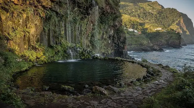
The reward at the far end is the Caldeirão Verde waterfall, dropping into a natural pool ringed by the same laurel forest you’ve been walking through. “Caldeirão” translates roughly as cauldron, and the name fits: a green, enclosed basin with water falling from a height into a cold pool below.
Swimming is possible when conditions allow and plenty of walkers do it, but the water stays cold throughout the year — this is a mountain-fed pool in a forest, not a beach — and the area can feel crowded around midday when day-trip groups from Funchal converge on the same spot. Arriving earlier in the day, which a Queimadas start naturally encourages, tends to mean more space at the falls.
There are no facilities at the waterfall itself: no changing rooms, no food stall, nothing beyond the pool and the surrounding rock. Whatever you plan to eat or drink at the far end needs to be carried in.
Who Should (and Shouldn’t) Attempt This
This walk suits a fit, comfortable walker who has budgeted the better part of a day and is prepared for tunnels and length rather than technical difficulty. It does not require scrambling, exposure to steep drops on narrow ledges, or a head for heights in the way that some of Madeira’s mountain routes do.
It’s a poor choice, though, for:
- Young children, given the total distance and the several unlit tunnel crossings
- Anyone strongly uneasy in enclosed, dark spaces
- Walkers with limited time who have confused this with a short levada like Balcões
- Anyone without proper footwear — the surface is often damp, and flip-flops or thin trainers are a genuine hazard here, not just discomfort
For a shorter, gentler introduction to walking beside a levada, Balcões from Ribeiro Frio or the paved section near Faial make far better first outings before attempting something at this length.
Getting to Queimadas
Queimadas sits above Santana on Madeira’s north coast, reached by a signed minor road from the Santana area. Public transport does not run to the car park itself, so realistic options are:
- Self-drive, which is the most flexible choice — the roads up from Santana are narrow but paved, and there’s a car park at the trailhead. See the general guide to driving in Madeira and car rental if you haven’t arranged a hire car yet.
- Taxi or private transfer, arranged in advance from Funchal or Santana, with a pick-up time agreed for the return.
- A guided tour, which handles transport, timing and the fee booking as part of the package — useful if you’d rather not manage the logistics yourself.
Given the north coast’s weather, which is wetter and cloudier than the south on an average day, check conditions before setting out; the trail can close after heavy rain, and Madeira’s official IFCN trail status pages are the place to confirm it’s open on the day you plan to walk.
What to Pack
Because this is a long day rather than a short outing, the packing list runs longer than for a shorter levada walk:
- Head torch (not optional — four tunnels, none lit)
- Sturdy, grippy footwear rather than sandals or smooth-soled trainers
- More water than feels necessary — there’s nowhere to refill along the route
- A packed lunch or substantial snacks, since there’s no food available at Queimadas or at the waterfall
- A light waterproof layer, given the north coast’s cloud cover and forest drip
- Swimwear and a quick-dry towel if you intend to swim at the falls
- Cash or a booked confirmation for the trail fee, checked at the trailhead
For a broader packing list covering mountain temperature swings elsewhere on the island, see what to wear in Madeira’s mountains.
Booking a Guided Option
Walking independently from Queimadas is entirely possible for a confident, prepared walker, and this page covers what’s needed to do exactly that. For anyone who’d rather not manage tunnel torches, trail-fee bookings and timing alone, a guided option removes that planning layer and adds local commentary on the forest and the levada system along the way.
a guided levada hike to the Caldeirão Verde waterfall covers this exact route with a local guide managing pace and logistics.
If Caldeirão Verde is one stop on a wider hiking trip, it’s worth planning it alongside Madeira’s other signature routes. The guided hike between Pico do Arieiro and Pico Ruivo sits at the opposite end of the island’s walking spectrum — mountain ridgeline rather than forest levada — and pairs well as a second day out for anyone building a hiking-focused week. For something shorter to balance a demanding day like this one, a guided sunrise walk on the Levada dos Balcões covers a route a fraction of the length.
Caldeirão Verde: Questions Before You Go
How long is the Levada do Caldeirão Verde walk?
From the Queimadas car park it is roughly 13km there and back, on flat but narrow terrain, through four unlit tunnels. Most walkers need four to five hours including a stop at the waterfall, so treat it as a full-day outing, not a short afternoon walk.
Where does the walk start?
At the Queimadas car park and picnic area above Santana, on the north coast. There is no public transport stop here, so most visitors arrive by hire car, taxi or a booked transfer.
Is this the same length as the Levada dos Balcões?
No. Balcões is a short loop of under 2km that most people finish in an hour. Caldeirão Verde is roughly seven times longer, with tunnels and a remote setting, and the two should never be confused when planning a day.
Do I need a torch or head torch?
Yes. The route crosses four tunnels cut into the rock, none of which are lit, and the longest runs for several minutes of walking in the dark. A head torch is the one item this walk cannot be done without.
Is the path suitable for children or nervous walkers?
The path itself is level, but its length, unlit tunnels and unprotected drops beside the channel in places make it a poor choice for young children, anyone uneasy underground, or walkers not used to being out for most of a day.
Do I need to pay to walk this levada?
Yes, this is one of Madeira’s official PR trails and carries the standard per-person, per-trail fee, booked online in advance and checked at the trailhead. Budget and book this before you drive up.
What is waiting at the end?
A waterfall dropping into a natural pool at Caldeirão Verde, reached after the fourth tunnel. Many walkers swim if conditions allow, though the water is cold year-round and the pool can be busy at midday.
Can I do it as a one-way walk with a pick-up?
Some guided tours arrange a one-way itinerary or transfer, cutting the return leg. Walking independently, almost everyone retraces the same path back to Queimadas, which is what the 13km figure accounts for.
tours.levada-walks
Verified deep-linked GetYourGuide tours. Book through these links and we earn a small commission at no cost to you.
GetYourGuide does not provide a product photo for this activity — the image shows the meeting point, photographed by us.