A Day Trip to the North: Santana, São Vicente & Ribeiro Frio
Can you do Santana, São Vicente and Ribeiro Frio in one day from Funchal?
Yes, but budget a full day, not a half-day. The three stops sit roughly 70-90 km apart on winding mountain roads, and the north takes far longer per kilometre than the tunnelled south-coast VR1. Leave by 8:30am and expect to be back after 6pm.
Why the north eats more of your day than the map suggests
Look at a road map of Madeira and the north seems close: Santana, São Vicente and Ribeiro Frio all sit within an hour or two of Funchal, in a cluster that looks like a tidy loop. It isn’t tidy in practice. The south coast has the VR1, a fast tunnelled expressway that turns Funchal-Machico or Funchal-Ribeira Brava into a 20-minute hop. The north has none of that. Roads climb out of ravines, switchback around headlands, and narrow to a single lane with passing places through villages that were never built with cars in mind. A stretch that measures 15 km on the map can easily take 30 to 40 minutes. Treat this page as a route plan built around that fact, not around the straight-line distances a map app will quote you.
The three anchor stops are covered in more depth on their own pages, and it’s worth reading those before you go: Santana and the thatched houses for what the casas de colmo actually are, and the Levada dos Balcões guide for the short walk at Ribeiro Frio. This page is about stitching the three together into one realistic day, with the driving time built in rather than glossed over.
Planning the loop: distances versus real driving time
The honest version of the itinerary looks like this. Times assume no major queues, no roadworks, and a driver who isn’t rushing the bends.
| Leg | Distance | Realistic driving time |
|---|---|---|
| Funchal to Santana | ~45 km | 1h–1h15 |
| Santana to São Vicente | ~25 km | 35–45 min |
| São Vicente to Ribeiro Frio | ~30 km | 45–55 min |
| Ribeiro Frio to Funchal | ~25 km | 30–40 min |
Add up the driving alone and you’re at roughly 3 hours 30 minutes to 4 hours behind the wheel, before a single stop. That leaves a workable but not generous window for the stops themselves if you want to be back in Funchal for dinner. Leave Funchal by 8:30am. A 9:30am or later start pushes the whole day back and tends to mean rushing São Vicente or skipping Ribeiro Frio altogether — which is the single most common mistake with this route.
If four hours of mountain driving on unfamiliar roads sounds like the wrong way to spend the day, a guided option removes that variable entirely: a guided day tour through Santana and the east covers this ground with a driver who already knows where the road narrows and where the viewpoints are worth the stop.
Stop 1: Santana and the thatched houses
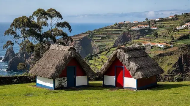
Santana is the visual anchor of the day: a farming village on the north slope known for its casas de colmo, the small triangular houses with steeply pitched thatched roofs, painted red, white and blue. A handful sit in the village centre and are open to visit — worth being clear about, since they’re maintained reconstructions rather than lived-in originals. Most residents of Santana live in ordinary housing; the thatched houses are a heritage display, not a snapshot of daily life. The full story of why they were built this way, and which ones you can actually walk into, is on the dedicated Santana thatched houses guide.
Santana also anchors this whole stretch of coast for things to do in the area, from short walks to the nearby theme park aimed at families. If children are along for the day, a private tour that pairs Santana with the theme park visit is built around exactly that combination, and takes the parking and timing pressure off a family group trying to do it independently.
Budget 45 minutes to an hour in Santana itself: enough to see two or three of the thatched houses, walk the small village centre, and get a coffee before the next leg. Parking is limited on peak-season days, so arriving before 10:30am helps.
Stop 2: São Vicente and the lava caves
From Santana, the road drops west toward São Vicente, a village at the mouth of a river valley on the north coast. The draw here is underground: the São Vicente Caves are lava tubes formed by volcanic activity roughly 890,000 years ago, walked on a lit path of around 700 metres with an attached volcanism centre that explains how the tubes formed. Unlike a levada tunnel, this route is lit and managed as a visitor attraction, so no torch is required — a useful distinction, since Madeira’s other tunnels (on the PR1 mountain trail, for instance) are unlit and demand a headlamp.
Allow around an hour for the caves and centre, plus a short stop in São Vicente village itself, which has a pleasant small square and a river running through the centre of town. This is roughly the midpoint of the day, and a sensible place to eat lunch before turning east and climbing back up into the mountains.
Stop 3: Ribeiro Frio and the Levada dos Balcões
The final leg climbs from São Vicente back up into the central massif to Ribeiro Frio, a cool, forested hamlet built around a trout farm and a cluster of small restaurants. This is the base for one of the shortest and easiest official walks on the island: the Levada dos Balcões, a level path of well under an hour there and back that ends at a viewpoint looking straight across at Pico do Arieiro and Pico Ruivo. For the time it takes, it’s arguably the best view-to-effort ratio of any walk in Madeira, and it’s covered stop by stop in the Levada dos Balcões guide.
Like every official PR-numbered trail on the island, this one requires the standard trail fee and online booking; it isn’t a walk you turn up to and simply start, and treating it as free is one of the most common mistakes visitors make on this route. Ribeiro Frio is also a good spot to sit down properly: the trout restaurants here are a minor institution, and after three driving legs it’s worth the twenty minutes.
If the idea of combining a sunrise summit with this same north-central ground appeals more than a village-and-caves day, a sunrise tour that pairs Pico do Arieiro with Levada dos Balcões and Santana covers similar territory from a different angle, starting well before dawn.
Optional detour: Porto da Cruz
If the day is running ahead of schedule — an early enough start and no major hold-ups — Porto da Cruz sits just off the return route toward Funchal, on the coast below Santana. It’s a small fishing village with a striking basalt headland and a laid-back surf scene, and makes a reasonable extra half hour if the rest of the day has gone to plan. It is not a stop to force in if you’re already running late; better to skip it and arrive in Funchal in daylight than add a fifth stop to an already full loop.
Driving the north: what actually slows you down
The north coast’s old road (much of it now bypassed in places, but not everywhere) runs through village centres rather than around them, narrows over old stone bridges, and includes stretches with no realistic overtaking. Add rain — common on this side of the island even when Funchal is dry — and visibility and grip both drop. None of this is dangerous with a careful pace, but it is slow, and it punishes a schedule with no slack built in.
A few points worth planning around:
- Choose a small car. The advice on car rental in Madeira applies with extra force on this route: a compact hire is easier to place on narrow bends and in tight village parking than anything larger.
- Expect manual gearboxes and real gradients. The general notes on driving in Madeira cover what to expect from the road network island-wide; the north is where those warnings matter most.
- Dress for a different climate than Funchal’s. The mountain weather guide is written for the high peaks, but the same logic applies at Ribeiro Frio and along the northern ridge roads: pack a layer regardless of how the day starts in Funchal.
- Don’t schedule a sunset arrival back in Funchal. If the day is running an hour behind by São Vicente, drop Porto da Cruz and head straight for Ribeiro Frio, or drop Ribeiro Frio and head straight home. Deciding which stop to cut in the car, at speed, is worse than deciding it in advance.
For a first-person account of exactly this kind of miscalculation, an honest take on driving in Madeira is worth five minutes before you set off.
Self-drive or guided: which suits this route
This particular loop is one of the better arguments on the island for considering a guided day out. The driving is genuinely more demanding than the south coast, the three stops are spread wide enough that missing a turn costs real time, and Santana’s village parking fills earlier than visitors expect. A guided minibus removes all three problems at once.
a guided bike route along the north coast forest and coastline is a more active alternative for anyone who’d rather cover this ground on two wheels with support than behind a wheel, and for a food-focused variant on the same corner of the island, a Santana wine-tasting and harvest lunch turns the Santana stop into the centrepiece of the day rather than a quick photo stop.
Self-driving still wins on flexibility: you can linger at Ribeiro Frio, skip São Vicente if the caves don’t appeal, or add Porto da Cruz on a whim. For a wider comparison of what each side of the island demands from a driver, see north versus south Madeira, and for a broader sense of which viewpoints are worth building a day around, the best viewpoints and miradouros guide covers several that sit along or near this route.
Whichever way you travel, the north rewards patience over speed. The thatched roofs of Santana, the cool dark of the São Vicente caves and the trout-farm calm of Ribeiro Frio are three of the most distinct scenes on the island, and none of them are improved by arriving rushed.
FAQ: north Madeira day trip to Santana, São Vicente and Ribeiro Frio
How far is Santana from Funchal, and how long does it actually take?
Around 45 km, but budget 1 hour to 1 hour 15 minutes each way. Part of the route uses fast tunnels, but the last stretch into Santana narrows and slows considerably.
Is one day enough to see Santana, São Vicente and Ribeiro Frio?
It is possible but tight. Most visitors who try to add a fourth stop, such as Porto Moniz, end up rushing at least one location or driving the last leg after dark.
Are the thatched houses in Santana real homes people live in?
A handful of casas de colmo are maintained as visitable reconstructions in the centre of the village. Most Santana residents live in ordinary modern housing; the triangular thatched houses are a heritage display, not the norm.
Do I need a torch for the São Vicente caves?
No, the lava tube route is lit and walked as a guided or self-guided path with a visitor centre attached, unlike an unlit levada tunnel.
Is the Levada dos Balcões walk suitable for a short stop?
Yes. It is one of the shortest and easiest official levada walks on the island, roughly an hour there and back from Ribeiro Frio, with one of the best mountain views for the effort involved.
Why do north-coast distances take so much longer than they look on the map?
The roads climb, switchback and narrow village by village, and stretches of the old coastal route are single-lane with passing places. A 20 km stretch here can take 40 minutes where a similar distance on the VR1 tunnel road takes 15.
Is it better to self-drive this route or book a guided tour?
Self-driving gives control over timing but demands confident mountain driving and a realistic schedule. A guided minibus tour removes the driving stress and the parking search in Santana, at the cost of a fixed itinerary.
What’s the weather like on this route compared with Funchal?
Expect it to be cooler and wetter than Funchal at every stop. The north side of Madeira catches the moisture the mountains pull from the Atlantic, so pack a layer even if Funchal is bright and dry when you leave.
Day trips to Porto Santo on GetYourGuide
Verified deep-linked GetYourGuide tours. Book through these links and we earn a small commission at no cost to you.
GetYourGuide does not provide a product photo for this activity — the image shows the meeting point, photographed by us.