Farmland in the clouds: what Canhas actually is
Canhas sits in the hills directly above Ponta do Sol, on the belt of cultivated slopes that climbs from the south coast toward the interior of Madeira. It belongs firmly to the island’s west, the same stretch covered by a west Madeira day trip that also takes in Ribeira Brava, Calheta and Madalena do Mar.
What makes Canhas worth naming on a map, rather than folding it silently into the drive, is what it is used for: this is agricultural country, worked in narrow terraces up steep ground, and it happens to sit on the road that most self-drive visitors use to reach the Paul da Serra plateau.
It is important to be clear about what Canhas is not. It has no single monument, no marked viewpoint that draws coach parties, and no waterfall or pool that anchors a visit the way 25 Fontes or the Porto Moniz pools do further along the coast. Guidebooks that treat Canhas as a destination in its own right, or promise sweeping panoramas from its lanes, are overselling it. What it offers instead is a genuine look at how this side of the island still feeds itself, plus a natural, unhurried place to break a longer drive before the road climbs into the mountains.
Terraces, not a terrace bar: how the land is worked
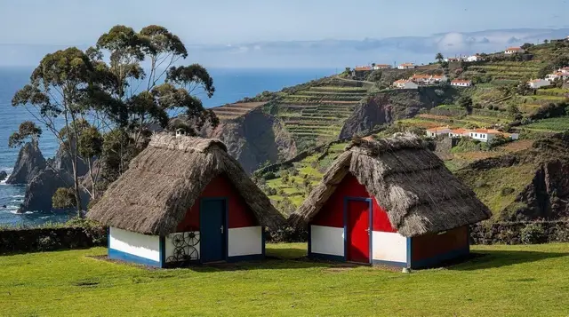
The defining feature of Canhas and the slopes around it is the poio, the dry-stone terrace that has been cut into Madeira’s hillsides since the earliest Portuguese settlement of the island in the fifteenth century. On land this steep, a flat field simply does not exist naturally, so generations of farmers built one, wall by wall, stacking soil behind stone retaining walls until a staircase of small plots climbed the mountainside. Around Canhas that staircase carries bananas and vines lower down, where the microclimate is warmest, giving way to vegetables, fruit trees and smallholder plots as the altitude increases.
None of this would be possible without water, and that brings the terraces of Canhas into the same story as the rest of the island: the levada network. These irrigation channels, first dug from the fifteenth century onward to carry water from the wet north to the dry south, pass through and above this farmland, feeding it drop by drop along contour-hugging courses. Understanding how levadas actually work helps make sense of the landscape here even if you never set foot on one near Canhas itself — the water in these terraces almost certainly arrived by the same engineering that carries hikers across the mountains elsewhere on the island.
Because the terraces are still farmed, not maintained as a museum piece, what you see changes with the season and with the weather. A dry spell shows exposed red earth and stone; after rain the same slopes turn a deep, saturated green. Neither state is more “authentic” than the other, and neither should be promised in advance — this is working land, not a landscaped garden.
Getting there from the coast
Canhas is reached most easily by car. From Funchal, the fastest route follows the VR1 west past Ribeira Brava before turning inland and climbing on minor roads, a drive of around thirty-five to forty-five minutes depending on traffic through the coastal tunnels. From Ponta do Sol itself the climb up to Canhas is short but steep, winding through terraces on a narrow lane, and it is over within about ten minutes.
Public transport reaches the area only thinly, with buses serving the main coastal towns far better than the farming hamlets above them, so a hire car is close to essential if Canhas is on your list. If you have not driven in Madeira before, it is worth reading the practical guide to driving on the island before setting off — steep gradients, hairpins and narrow single-track sections are the norm here, not the exception, and choosing the right hire car matters more on roads like this than it does on the flatter south coast.
The road on to Paul da Serra
The main reason most travellers pass through Canhas at all is that it sits on one of the routes climbing from the south coast up to the Paul da Serra plateau, Madeira’s only expanse of open, high-altitude ground. From the terraces around Canhas, the road gains altitude quickly, and the landscape changes with it: cultivated slopes give way to laurel woodland, then to the bare, wind-scoured moorland of the plateau itself.
This page is deliberately not the place to describe that plateau in detail, its flatness, its wind, or the mist that gathers around Fanal at its edge — those belong to the destination page for Paul da Serra itself, and it is worth reading that before you commit to the climb. What matters here is the transition: Canhas and the farmland around it is where the cultivated, inhabited Madeira you have been driving through starts to thin out, and where the character of the island changes from village and terrace to open moor. Treat the drive through Canhas as the approach, not the event, and save your expectations for what is above.
One practical point carries over from the plateau back down to Canhas: weather here can shift fast with altitude. Sun on the coast at Ponta do Sol says nothing reliable about conditions a few hundred metres higher, and cloud can close in on the upper road within minutes. It is sensible to check what the mountains are doing and what to wear for them before you commit to the full climb, and to have a fallback plan on the coast if the upper road is socked in.
Walking near Canhas: levadas, permits and realistic expectations
Canhas itself is not a hiking trailhead, and no official PR trail begins in the village. Walkers exploring this side of the island are better served a little further along, particularly around Serra de Água, where marked routes follow the levada network through steep, wooded valleys. A guided scenic levada walk around Serra de Água is a practical way to experience this kind of terrain without navigating tunnels and exposed sections alone, and it sits close enough to Canhas to combine easily with a morning on the terraces.
If a longer, wilder outing appeals more, a guided hike to some of Madeira’s hidden waterfalls covers similar west-side terrain further into the valleys, again with a guide handling the navigation and the safety calls that unmarked or lesser-known routes demand.
Whichever levada route you choose in this part of the island, remember that Madeira’s official PR trails have not been free since August 2021: expect a fee of around three euros per person, per trail, per day, booked online in advance and checked on the ground. The full rules on permits and trail fees are worth reading before you plan a walking day here, since this is the single detail that most catches first-time visitors out. Trails also close after heavy rain or rockfall, so it is worth checking current conditions rather than assuming a route on a map is open.
Where Canhas fits into a west-coast day
The most useful way to think about Canhas is as one stop within a longer loop rather than a destination that justifies its own outing. A typical day might run from Funchal along the coast through Ribeira Brava, up into the terraces at Canhas, on toward the plateau road as far as conditions and time allow, then back down to finish at Calheta or the fishing village of Paul do Mar on the west coast. A full west Madeira day trip itinerary lays out that kind of route in more detail, with Canhas as one waypoint among several rather than the headline stop.
For travellers who would rather leave the driving and the route-planning to someone else, a guided sunset jeep tour down to Paul do Mar covers much of this same west-coast ground, timed to end at the coast as the light drops. Things to do around Paul do Mar rounds out the options at that end of the route for anyone extending the day beyond the farmland at Canhas.
Practicalities: budget, timing and what to pack
A stop at Canhas costs almost nothing beyond fuel and time — there is no entrance fee to the village or the terraces, and the only charge to plan for is the trail permit if you continue on to an official PR route elsewhere. Budgeting for a half-day loop through this area, including fuel, a coffee stop and a modest lunch, works out at roughly forty to seventy euros per person, with a hire car as the main separate cost on top.
The best months to see the terraces at their greenest are April to June and again September to October, avoiding both the driest stretch of high summer and the wettest, cloudiest weeks of midwinter. Even so, no season here guarantees a clear run to the top: pack a layer for altitude, keep an eye on cloud building over the hills, and treat any promise of an open panorama from Canhas itself with scepticism — the real views, when the weather allows them, belong to the plateau above, not to the farmland you pass through to reach it.
Canhas and the road to Paul da Serra: your questions answered
Is Canhas worth a special trip on its own?
Not really. Canhas has no single headline sight, and it earns its place on an itinerary as part of the drive between Ponta do Sol and the Paul da Serra plateau, rather than as a standalone destination.
What is there actually to see in Canhas?
Terraced smallholdings climbing the slope, small chapels, and working farmland growing vines, bananas and vegetables on land too steep for machinery. It is a working landscape, not a curated viewpoint.
Can I walk from Canhas up to the Paul da Serra plateau?
There is no signed official PR trail running directly from Canhas onto the plateau. Walkers usually drive up and start from a marked trailhead higher on the road, using Canhas only as a lower waypoint on the way.
Is there a levada walk near Canhas?
The nearest waymarked levada walking is around Serra de Água and Ribeira Brava rather than in Canhas itself. It is more accurate to think of Canhas as farmland that the levada network passes through than as a walking destination in its own right.
How do I get from Canhas down to Ponta do Sol?
It is a short, steep drive of around ten minutes down to the coast at Ponta do Sol, following minor roads through the terraces before joining the main coastal route.
Do I need a permit to walk near Canhas?
Only if you join one of Madeira’s official PR trails, which have required a paid, pre-booked permit since August 2021. Simply driving through or stopping in Canhas itself needs no permit.
Is the road from Canhas up to Paul da Serra open in winter?
Usually yes, but it climbs quickly into cloud and can be closed or hazardous after heavy rain. It is worth checking conditions before committing to the upper road between November and March.
Where should I stay if I want to explore this area?
Most travellers base themselves down on the coast in Ponta do Sol, Calheta or Ribeira Brava and treat Canhas as a stop on a driving day, rather than staying up in the farmland itself. For those wanting a private, guided way to see the wider region — terraces, valleys and the plateau road together — a full-day private 4x4 tour is a practical option that removes the need to self-navigate the steepest sections.