Most visitors arrive at a levada path expecting a pretty walk and leave having barely noticed they spent the morning inside one of the rarest forests on the planet. The trees pressing in on both sides of the trail, dripping with moss and threaded with pale lichen, are not simply scenery for the walk. They are the reason the walk is possible at all.
A Rainforest That Outlived the Ice Ages
The Laurissilva is a laurel forest, a type of subtropical woodland that once stretched across a broad band of southern Europe and North Africa during the Tertiary period, tens of millions of years ago, when the climate there was warmer and wetter than it is today. As the ice ages advanced, that climate collapsed on the mainland and the forest died with it almost everywhere. It survived only on a handful of Atlantic islands, Madeira chief among them, where the Gulf Stream and the trade winds kept conditions close enough to the original to let the forest carry on largely unchanged.
That continuity is the whole point. Walking into the Laurissilva is not like walking into a forest that regrew after being cleared, or one that has been shaped by centuries of managed planting. It is closer to walking into a fragment of a world that no longer exists anywhere else at this scale, still running on the same species and the same relationships between plant, fungus, insect and bird that were in place before humans existed. That is why UNESCO’s 1999 inscription describes it as the largest surviving area of primary laurel forest on Earth, not merely a good example of one.
Where the Forest Lives on the Island
The Laurissilva covers roughly 15,000 hectares, close to a fifth of Madeira’s total land area, and it is heavily weighted toward the island’s north slope, where rain clouds driven in off the Atlantic hit the mountains and drop their moisture most reliably.
The result is a forest belt that runs, with breaks and thinning at the edges, from the cliffs above Porto Moniz in the west through the high interior around Paul da Serra and Fanal, across the flank below Pico Ruivo and Pico do Arieiro, and down toward Santana and the Queimadas park in the east.
The south coast, by contrast, has almost none of it left. Centuries of clearing for sugar cane, banana and vineyard terraces stripped the original vegetation from the sunnier, drier southern slopes long before anyone thought to protect what remained. What survives today is, in effect, whatever the terrain made too steep, too wet or too remote to be worth clearing, which is precisely why so much of it sits above 700 metres, wrapped around ravines and hidden inside cloud for a large part of the year.
The Trees, the Fog and the Water They Make
The forest is built around a small set of tree species found only on Macaronesia: til (Ocotea foetens), vinhático or Madeira mahogany (Persea indica), barbusano (Apollonias barbujana) and various species of loureiro or true laurel (Laurus species), among others. These are not the low scrub you might picture from the word “laurel” in a garden context; mature til trees inside the forest reach heights and girths that make them feel closer to temperate rainforest giants than to anything ornamental.
What sets the Laurissilva apart from an ordinary woodland is how it interacts with the fog. The dense, layered canopy intercepts moisture directly from passing cloud, a process called horizontal or occult precipitation, which adds significantly more water to the ground than rainfall alone would provide. That extra water feeds the springs and streams that the island’s levada network was built to capture, meaning the forest is not just scenery beside the irrigation channels but the reason those channels have water to carry in the first place. Losing the Laurissilva would not just be an aesthetic loss; it would measurably change how much water reaches the farms and towns on the drier south coast.
The undergrowth below the canopy is thick with ferns, mosses and endemic shrubs that thrive in near-constant humidity, and the whole system supports wildlife that exists nowhere outside this habitat. The Madeira firecrest, a tiny endemic bird, and the trocaz pigeon, a laurel-forest specialist found only here and on a few neighbouring islands, both depend on the mature forest structure to nest and feed. Below them, an unusually rich community of endemic invertebrates and land snails lives in the leaf litter and damp bark, most of it studied only in the last few decades.
Why the UNESCO Listing Matters
UNESCO added the Laurissilva to the World Heritage list in 1999, citing both its scale, as the largest continuous remnant of primary laurel forest anywhere, and its exceptional concentration of endemic species relative to its size. That listing is not a ceremonial label. It sits inside a wider protected area, managed with the Madeira Natural Park, that restricts logging, grazing and development across most of the forested zone and requires permits for the official trails that pass through it.
It is worth being direct about what this means for how the forest should be described. It is easy, in a week built around waterfalls and viewpoints, to file the Laurissilva mentally under “nice trees on the way to the good bit.” That framing undersells it. The forest is the rare thing here, not the backdrop to the rare thing, and the trails that cross it are, more accurately, visitors passing briefly through a protected ecosystem rather than the ecosystem existing to decorate the trails.
How People Actually Experience the Forest
Almost nobody visits the Laurissilva as an abstraction; they experience it by walking one of the paths that cross it, and each of the main access points gives a slightly different version of the forest.
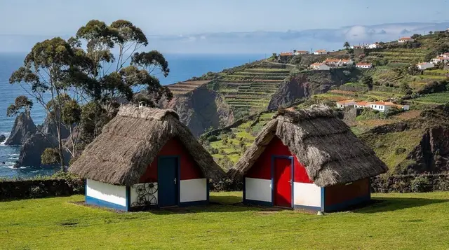
Rabaçal, reached by a shuttle from the car park because the access road is closed to private cars, sits deep inside dense, dripping forest and is the starting point for some of the island’s best-known levada walks, including the routes to the 25 Fontes waterfalls and the Levada do Risco. The Queimadas park near Santana, with its thatched houses set against a wall of green, is the starting point for the long walk to Caldeirão Verde, one of the more sustained stretches of unbroken forest on the island. Ribeiro Frio, a former trout hatchery turned trailhead in the central mountains, gives a gentler, more open introduction to the forest via the short walk to Balcões, or a much longer traverse for those with a full day.
For a different register entirely, Fanal sits at the northwestern edge of the Paul da Serra plateau, where centuries-old til trees have been twisted into shapes by wind and mist. When the fog rolls in, Fanal is the single most photographed corner of the forest on the island; without it, the same trees stand in flat daylight and the effect is considerably less dramatic, so it pays to treat a foggy Fanal visit as good luck rather than something you can plan around with certainty.
A jeep tour through Santana and the high interior is one practical way to reach several of these points, forest and viewpoints included, in a single organised day; the jeep tour through Santana toward Pico do Arieiro covers a good stretch of this ground for anyone who would rather not drive the mountain roads themselves.
Walkers heading specifically for the Fanal side of the forest, along the PR13 route, can also book the guided PR13 hike to Vereda do Fanal with transfer from Funchal, which removes the need to arrange the drive up to the plateau independently. A longer, more demanding option through the eastern reaches of the forest is the full-day guided hike from Ribeiro Frio to Portela, which spends most of its distance under canopy rather than on open ridgeline.
Fog, Sun and the Mountain Air Above the Forest
Because the Laurissilva sits mostly on the humid north slope and climbs into the mid-altitude cloud belt, its weather behaves differently from either the sunny south coast or the exposed peaks above it. Mist can settle in for hours and then clear within minutes; a trail that looks socked in from the car park can open onto full sun a kilometre further along, and the reverse happens just as often.
This is also the altitude band where several operators run tours built around watching the cloud layer itself, rather than walking through it. The sunrise tour above the clouds departs before dawn to reach a viewpoint over the same cloud cover that feeds the forest below, which is a useful way to understand how the whole system fits together: the fog that soaks the Laurissilva by night is often the same fog visitors are driving up to stand above at sunrise.
Because conditions shift quickly and the paths are often narrow, uneven and shaded, it is worth checking current trail status before setting out rather than assuming yesterday’s conditions still apply; what to wear in the mountains and trail safety on levada paths both cover this in more detail, and are worth reading before a first visit.
Access Points at a Glance
| Access point | Character of the forest | Typical trails from here | Difficulty |
|---|---|---|---|
| Rabaçal | Dense, dripping, classic laurel forest | 25 Fontes, Levada do Risco | Moderate |
| Queimadas | Thick, sustained canopy | Caldeirão Verde | Moderate to hard |
| Ribeiro Frio | Open, mixed, easy introduction | Balcões, longer eastern routes | Easy to hard |
| Fanal | Wind-shaped, misty, sparser canopy | Short walks around the til grove | Easy |
| Encumeada | Ridge-edge forest with wide views | Connecting routes toward Rabaçal | Moderate |
Planning a Forest Visit
A visit built around the Laurissilva works well as a half-day if you are choosing one access point and one short walk, or a full day if you are combining a forest trail with a viewpoint or a village stop nearby. Because most of the access roads climb steeply and some, like the one to Rabaçal, exclude private cars entirely, this is one part of the island where a guided trip or a shuttle genuinely simplifies the day rather than just adding cost. Independent drivers should budget extra time for narrow mountain roads and should not expect mobile signal for long stretches once inside the forest.
The trail permit system introduced in August 2021 applies to the official PR-numbered paths that cross the forest, at roughly three euros per person, per trail, per day, booked online in advance and checked at the trailhead. It does not apply to every path inside the protected area, but it does apply to the best-known ones, including the routes from Rabaçal and Queimadas described above, so it is worth checking before assuming a walk is free. Layered, waterproof clothing is worth packing regardless of the forecast at sea level; humidity and shade inside the canopy keep temperatures noticeably cooler than Funchal, even on a day that starts out warm and clear on the coast.
For travellers who want the ecology explained rather than assumed, the UNESCO Laurissilva forest guide goes deeper into the science and conservation history, while the island’s endemic wildlife and birdwatching guide covers what to look and listen for once you are under the canopy.
Anyone building a full trip around walking should also read the best levada walks on the island and the guide to hiking permits and trail fees before booking anything, and those planning a dedicated week on foot may prefer to start from the hiking week itinerary rather than piecing routes together on the fly. The broader Laurissilva and nature activities category lists further ways to experience the forest beyond walking, including guided naturalist trips.
Laurissilva Forest: Your Questions Answered
What is the Laurissilva forest, in one sentence?
It is a laurel forest descended from the subtropical woodland that once covered southern Europe and North Africa in the Tertiary period, now surviving almost nowhere else at this scale, and it covers close to a fifth of Madeira.
How old is the Laurissilva forest?
The forest type is millions of years old, a relic of vegetation that vanished from mainland Europe during the ice ages but persisted on Madeira and the other Macaronesian islands thanks to their mild, humid climate.
Why is the Laurissilva a UNESCO World Heritage Site?
UNESCO inscribed it in 1999 because it is the largest surviving area of primary laurel forest anywhere in the world, at around 15,000 hectares, and because of its exceptional concentration of plant and animal species found nowhere else.
Where is the best place to see the Laurissilva forest?
The forest is mostly on the north slope, and the classic access points are Rabaçal, the Queimadas park near Santana, Ribeiro Frio, and the misty plateau edge at Fanal, each reached by a different road and a different trail.
Is the Laurissilva forest the same as a levada walk?
No. The forest is the ecosystem itself; the levadas are irrigation channels with paths beside them that happen to pass through parts of it, and several of Madeira’s best-known walks, such as the 25 Fontes and Caldeirão Verde routes, run through Laurissilva without being the forest itself.
Do I need a permit to walk in the Laurissilva forest?
You don’t need a permit simply to be in the forest, but the official PR trails that cross it, including the ones through Rabaçal and Queimadas, have required a paid trail permit since August 2021, booked online and checked at the entrance.
What animals live in the Laurissilva forest?
It shelters species found only on the island or the wider Macaronesian archipelagos, including the Madeira firecrest, the trocaz or laurel pigeon, and a range of endemic invertebrates and land snails that depend on the forest’s constant humidity.
Can you visit the Laurissilva forest without hiking?
You can see it from the road at several points, particularly around the Paul da Serra plateau edge near Fanal and along the Encumeada pass, but experiencing the forest properly still means walking one of its trails on foot.